




Abstract: The underwater domain is critical in shaping maritime dominance which directly influences the ability to sense and interpret ocean state that enhances detection, deterrence and operational decision-making. Sea gliders can contribute significantly in this space. Operating autonomously for months, they profile temperature, salinity and pressure to generate high-resolution Sound Velocity Profiles (SVPs) that are essential for sonar performance, submarine routing and Anti-Submarine Warfare (ASW) planning. Under India’s Deep Ocean Mission (DOM), institutions such as Indian National Centre for Ocean Information Services (INCOIS) and National Institute of Ocean Technology (NIOT) have already demonstrated the reliability of these systems for long-endurance scientific observation. The Indian Navy (IN) demands continuous, operationally relevant environmental intelligence. This requirement has gained renewed momentum with the launch of GSAT-7R which provides a secure, indigenous, multi-band communication backbone capable of linking autonomous assets directly to naval networks. In parallel, IN now possesses complementary platforms such as Wave Glider that can relay data utilising GSAT-7R without interruption enabling a persistent subsurface and surface observation pair. The article proposes a hybrid national model aligning the MoD and MoES to integrate sea gliders into Indian Navy operations. By leveraging existing scientific infrastructure for real-time ocean data, it offers a cost-effective, feasible approach that enhances UDA, strengthens ASW capability, and supports a self-reliant, data-driven underwater strategy.
Introduction
The underwater domain is critical in shaping maritime dominance which directly influences the ability to sense and interpret ocean state that enhances detection, deterrence and operational decision-making. Sea gliders can contribute significantly to this space. Operating autonomously for months, they profile temperature, salinity and pressure to generate high-resolution Sound Velocity Profiles (SVPs) that are essential for sonar performance, submarine routing and Anti-Submarine Warfare (ASW) planning. Under India’s Deep Ocean Mission (DOM), institutions such as Indian National Centre for Ocean Information Services (INCOIS) and National Institute of Ocean Technology (NIOT) have already demonstrated the reliability of these systems for long-endurance scientific observation. The Indian Navy (IN) demands continuous, operationally relevant environmental intelligence. This requirement has gained renewed momentum with the launch of GSAT-7R which provides a secure, indigenous, multi-band communication backbone capable of linking autonomous assets directly to naval networks. In parallel, IN now possesses complementary platforms such as Wave Glider that can relay data utilising GSAT-7R without interruption enabling a persistent subsurface and surface observation pair. The article proposes a Hybrid National Model that aligns the Ministry of Defence (MoD) and the Ministry of Earth Sciences (MoES). It offers a financially economical and operationally feasible approach to integrate sea gliders in IN Operations. The concept leverages existing scientific capabilities and ensures that ocean data is available to naval users in real-time. The study concludes that sea gliders can substantially enhance Underwater Domain Awareness (UDA), strengthen ASW capabilities and aid towards the broader objective of a self-reliant, data-driven underwater strategy for the Indian Navy.
Competing for the Unknown: The Race to Map the Indian Ocean
Underwater awareness is rapidly becoming the next frontier of maritime capability. And yet it remains the most opaque.1 Unlike the surface or the skies, the sub surface’s properties are not constant. The ocean's "acoustic weather"- its temperature, salinity and pressure - changes daily, seasonally and locally. Figure 1 shows how salinity changes with depth across different regions is shaping the ocean’s “acoustic weather.” These variations bend sound rays to create shadow zones, thermal layers and sound ducts that directly influence ASW detection and submarine concealment2 for a submarine, these features are a lifeline for concealment; for an Anti-Submarine Warfare (ASW) hunter, they are a source of acoustic ambiguity and failure. In an era where information is central, the ability to understand and predict the subsurface environment has become as essential as command of the surface3

Fig 1: Profile of Ocean Salinity for Different Regions
Source: Sea Water | National Oceanic and Atmospheric Administration
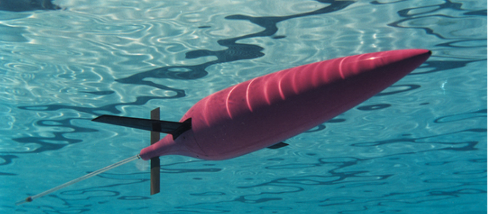
Traditionally, environmental data were collected through deployed ships, research vessels and moored buoys which are expensive, infrequent and limited in coverage. The one who maps this "acoustic weather" in real-time gains a decisive advantage. This is the core purpose of sea gliders. Sea gliders with their endurance and stealth can provide such data continuously and economically. By using buoyancy-driven propulsion instead of noisy propellers, they "fly" through the water column in a slow, sawtooth pattern, profiling the entire column from surface to depths of 1000 meters or more. On a single battery charge, they can do this for months, surfacing periodically to transmit their data. They are persistent, cost-effective and stealthy.
The numerical ocean models run by the Naval Operational Data Processing and Analysis Centre (NODPAC) churn out the ocean state forecast, but these models are constrained by a lack of continuous in-situ data for validation. Without this real-time ground truth, models can drift and their predictions of sonar ranges become unreliable. Sea gliders are the most practical, persistent and cost-effective tools to provide this validation. When assimilated into ocean models, this data improves predictions of sound propagation and underwater visibility - the bedrock of all ASW planning.4 The gliders deployed near chokepoints, littoral belts of the Arabian Sea/ Bay of Bengal and open ocean covering wider Indian Ocean Region (IOR), as decided by commanders, can deliver live updates of the ocean for assimilation into operational ocean models. Updated sound-velocity profiles refine sonar settings will guide aircraft in deploying sonobuoys and help submarines exploit shadow zones for concealment.5 Such environmental précise input reduces uncertainty and enhances detection probabilities with improved safety margins.6
India’s scientific agencies which include the Indian National Centre for Ocean Information Services (INCOIS) and the National Institute of Ocean Technology (NIOT) are already operating advanced sea gliders, yet this critical, real-time data is not reaching the war fighter.7 This institutional gap creates a tactical blind spot, one that China is actively exploiting by persistently mapping the IOR with its own Haiyi (Sea-Wing) gliders. The discovery and recovery of these gliders by Indonesian fishermen in 2019-20 confirmed that what Beijing frames as benign scientific research is, in fact, a strategic, dual-use data-gathering operation to map the sub-surface environment.8
GSAT-7R: Linking Science and Operations
The integration of Geosynchronous Satellite - GSAT-7R marks a turning point for India’s underwater network. Launched by ISRO on 02 November 2025, the satellite provides the Navy with a dedicated, high-bandwidth and encrypted communication grid.9 GSAT-7R carries multi-band Ka/Ku secure links, enabling near-real-time transmission of mission data within minutes while ensuring end-to-end encryption across naval networks. The gliders being used by INCOIS and NIOT are Slocum Gliders from Teledyne Webb Research, which rely on commercial Iridium satellite links (foreign origin) for command and telemetry.10 India can now close that strategic gap by linking autonomous assets directly into its own secure communication architecture.
In practical terms, GSAT-7R enables near-real-time data transfer from systems operating at sea to shore-based mission centres. The advantage is not just speed, but independence. Secure relay ensures that sensitive acoustic data (in case of gliders) remains within national networks, avoiding foreign routing or interception. The result is an unbroken data chain from sensors in the ocean to decision-makers ashore.
Operational Integration: A Hybrid National Model
Every emerging technology must prove its worth not in theory but in cost-efficiency and usability. In that sense, sea gliders are not only operationally effective but economically prudent. A single glider mission, once deployed, can operate autonomously for up to 180 days, collecting continuous data at a cost estimated to be significantly less than incurred for a conventional research vessel. Their persistence is the real advantage - they are the Navy’s “silent sentinels.”11
A fully militarised, Navy-owned-and-operated glider arm would be the traditional solution. However, the cost-effectiveness will be a question as it requires a new logistics and training pipeline and takes years to field. The immediate, high-value and cost-conscious solution is a "Hybrid National Model" that leverages existing national assets. This approach leverages MoES infrastructure for deployment and maintenance while enabling the Indian Navy to remain the primary tasker and operational user capitalising on existing national investments in sensors, satellites and data analytics. However, practical challenges such as inter-ministerial data-classification protocols, funding channels and mission-clearance cycles must be harmonised to enable smooth joint deployments. This model aligns naturally with India’s emphasis on inter-agency synergy across the Indo-Pacific.12
Internationally, this approach mirrors successful models like the US Navy’s Littoral Battlespace Sensing (LBS-Glider) programme and NATO’s CMRE (North Atlantic Treaty Organisation - Centre for Maritime Research and Experimentation) network, where science and defence institutions share assets.13 The LBS-G program, run by the Naval Meteorology and Oceanography Command (CNMOC), operates a fleet of over 200 gliders. This "Glider Operations Center" functions 24/7, tasking gliders worldwide to provide real-time environmental data directly to P-8 Poseidon crews and submarine commanders, directly supporting ASW.14 By adapting the hybrid approach, the Indian Navy gains environmental data at low cost while preserving its operational independence.
This framework is built on a simple, pragmatic division of expertise, linking the scientific base of MoES with operational requirements of MoD:
-
MoES (INCOIS/NIOT). Continues to deploy, maintain and pilot the gliders. As the national experts, they manage the "science" and "asset maintenance" components in which they have attained expertise.15
-
Indian Navy (MoD). Becomes the primary user and tasker. Through a joint MoD-MoES tasking mechanism, the Indian Navy can request glider deployments in operationally relevant areas. NODPAC would receive the raw data in real-time via the secure GSAT-7R link for immediate assimilation into operational ocean models.
This "hybrid" approach avoids costly duplication, manages life-cycle costs and builds operational familiarity using assets already in the national inventory. It formally turns INCOIS and NIOT into force multipliers for the Navy. The operational insights gained would be immediate and profound. updated Sound Velocity Profiles (SVPs) predicted by ocean models post assimilation of glider data would:
-
Enhance ASW Operations. Allow P-8I aircraft to optimize sonobuoy patterns and depths, improving the efficiency of the op sorties. Surface combatants could fine-tune their sonar settings, increase detection ranges and reduce false contacts.
-
Support Submarine Operations. Provide our own submarines with "sanitised" transit lanes, allowing captains to exploit known shadow zones and thermoclines for maximum concealment.
-
Inform Planning. Allow NODPAC to generate more accurate acoustic range predictions, giving commanders a clear picture of the "acoustic weather" before an operation even begins.
Layering the Capability: Integrating Sea Gliders and Wave Gliders
The hybrid model can be made even more resilient by integrating an existing complementary platform of the Indian Navy i.e Wave Glider. While often confused, these two platforms are a perfect "networked pair."
-
Sea Glider. A subsurface AUV that silently profiles the deep-water column upto a period of 4 - 6 months but must surface to transmit data, creating a moment of vulnerability and using precious battery power.16
-
Wave Glider. An Autonomous Surface Vehicle (ASV) that uses wave energy for propulsion and solar panels for its electronics. It can stay on station for up to 12 months with very minimal period for turnaround, acting as a persistent surface gateway.17

Fig 2: Proposed Hybrid Underwater Observation Network
Source: Conceptualised by the Author and Generated using Open-Source Tools
The operational complementarity is transformative. A Sea Glider, instead of surfacing fully and transmitting via satellite, can perform a short-range, low-power acoustic data burst to a nearby Wave Glider. The Wave Glider then relays this data securely via GSAT-7R to the Ocean Model/ Data Centre as indicated in Fig 2, representing the model. This allows the Sea Glider to remain submerged, stealthy and on-task for longer periods.
The recent joint venture between Sagar Defence Engineering and Liquid Robotics (a Boeing company) to co-develop the Wave Glider in India under the United Sates - India defence partnership is aimed squarely at the UDA mission. Integrating the existing Slocum Sea Gliders with these new, indigenous Wave Gliders creates a multi-layered, persistent and highly survivable observation network.18
Enabling the Hybrid Model: Technology and Self-Reliance
The hybrid model can begin now with existing imported gliders (like the Teledyne Slocum) and the new Wave Gliders. The logical next step, as defined in the Unmanned Systems Roadmap 2021–2035,19 is to build on this model's success through Aatmanirbhar Bharat to scale the fleet and secure the national supply chain by creating an end-to-end domestic ecosystem.20
The Unmanned Systems Roadmap identifies autonomous platforms as central to surveillance. NIOT’s own engineering work on indigenous gliders, combined with private industry under iDEX (Innovations and Defence Excellence) and the Deep Ocean Mission, is creating an indigenous ecosystem.21 Companies such as Kalyani Strategic Systems Ltd. are progressing towards the manufacturing of AUVs optimised for Indian conditions, focusing on endurance and corrosion-resistant materials.22 Their communication suites can now be integrated with GSAT-7R, giving the Navy continuous encrypted connectivity across the Indian Ocean.23
The key is to ensure this indigenous development is not siloed. It must be guided by the joint MoD-MoES operational/ scientific requirements defined by the hybrid model. This ensures that new, Indian-made gliders are "born-digital," fully integrated with the GSAT-7R communication suite and directly serve the needs of the naval war fighter from day one, rather than being another science-only project.
Implications from a Naval Perspective
Beyond technology and cost, the pertinent question is: what difference will this make to the Indian Navy’s effectiveness? The answer lies in how sea gliders transform the Navy’s operations with information. With the glider’s deployment, environmental data can be continuous, indigenous and operationally integrated. The impact is multidimensional:
-
Operational. Better sonar calibration, improved submarine routing and optimised ASW search patterns.
-
Strategic. Enhanced deterrence posture - a Navy that “hears first, acts first.”
-
Economic. Lower cost of persistent surveillance compared to ships or aircraft.
-
Scientific. Strengthened national data repository supporting climate, fisheries and maritime safety.
The Road Ahead
Integration of sea gliders into naval operations must proceed in a phased manner with a practical approach towards improving operational efficiency utilising the scientific posture. The following roadmap (Table 1) translates this approach into concrete actions and quantifiable indicators, ensuring a structured progression towards full-spectrum naval integration.

Table 1: Phased Integration Plan for Sea Gliders in Naval Operations
Source: Author’s compilation from MoES, INCOIS and Indian Navy open-source data (2025)
Policy Recommendations
Establish a Dedicated MoD–MoES Coordination Cell to provide a single-point mechanism for unified tasking, faster approvals and streamlined deployment of autonomous systems.
Integrate GSAT-7R Secure Communications Suite across Autonomous Platforms to ensure encrypted, low-latency data relay to operational units, enabling real-time environmental updates and mission responsiveness.
Accelerate Development of an Indigenous Glider Fleet under Make-II/iDEX to build sovereign capacity reduce import dependencies and enable rapid scaling aligned with Navy–MoES mission requirements.
Create a National Undersea Observation Network under the SAGAR Framework to deliver continuous IOR-wide environmental monitoring and support cooperative regional security through responsible data sharing. The political and institutional commitment will be a key enabler in operationalising joint MoD-MoES efforts. By adopting this balanced hybrid approach, India can swiftly turn research instruments into operational sentinels, strengthening deterrence and ensuring maritime stability throughout the Indian Ocean. By uniting science and operations, India will be well-positioned to spearhead cooperative UDA initiatives across the broader Indo-Pacific, reinforcing its role as a responsible regional leader.
Conclusion
The integration of sea gliders into Indian Naval operations is more than a technological upgrade; it represents a conceptual shift. It moves the Navy from episodic observation to continuous awareness, from foreign data dependence to sovereign environmental control. The real innovation lies in the model - a hybrid, cost-efficient, scientifically rich framework where research and operations work as one ecosystem.
The GSAT-7R satellite, indigenised gliders and institutional collaboration creates the ingredients for a self-reliant underwater strategy. What remains is defining clear priorities, sustained funding and ensuring that glider data directly shapes operational decision-making. For the Indian Navy organisational value will show in measurable terms: improved sonar accuracy, quicker mission planning, safer submarine routes and reduced operational costs. At the national level, it will unify science, technology and security under a single cost-efficient framework.
As underwater competition intensifies across the Indo-Pacific, nations that understand the ocean will control it. For India, sea gliders are not simply instruments of research -- they are instruments of awareness, deterrence and sovereignty. Their quiet endurance may well define the next generation of maritime superiority.
Endnotes
-
Indian Navy, Ensuring Secure Seas: Indian Maritime Security Strategy (IMSS 2015) (New Delhi: Integrated Headquarters, Ministry of Defence (Navy), 2015).
-
Robert J. Urick, Principles of Underwater Sound, ed. 3rd (New York: McGraw-Hill, 1983).
-
“Naval Operations: Lessons from Recent Conflicts,” accessed November 13, 2025, https://euro-sd.com/2025/03/articles/43406/naval-operations-lessons-from-recent-conflicts/.
-
Ashlee Lillis and T. Aran Mooney, “Sounds of a Changing Sea: Temperature Drives Acoustic Output by Dominant Biological Sound-Producers in Shallow Water Habitats,” Frontiers in Marine Science 9 (August 2022), https://doi.org/10.3389/fmars.2022.960881.
-
Emlyn M. Jones et al., “Assimilation of Glider and Mooring Data into a Coastal Ocean Model,” Ocean Modelling 47 ( January 2012 ): 1 – 13 , https://doi.org/10.1016/ j.ocemod.2011.12.009.
-
“OCEANOGRAPHIC ENVIRONMENTAL ASSESSMENT USING UNDERWATER GLIDERS | Scilit,” accessed November 13, 2025, https://www.scilit.com/publications/5ef2e6b89a3dbe43e9133ff18c206379.
-
INCOIS, Annual Report 2023–24 (Hyderabad, 2024), https://incois.gov.in; NIOT, Annual Report 2023 (Chennai, 2023), https://niot.res.in.
-
The Jakarta Post, Indonesia Finds Chinese Underwater Drone near Selayar Islands, 2020, https://www.thejakartapost.com.
-
ISRO, “Successful Launch of GSAT-7R Satellite for the Indian Navy,” 2025, https://isro.gov.in.
-
Teledyne Marine, “Slocum Glider Overview,” 2024, https://www.teledynemarine.com.
-
“Smart Sea Gliders Improve Ocean Observation and Ocean Prediction,” U.S. Naval Research Laboratory, accessed November 13, 2025, https://www.nrl.navy.mil/Media/News/Article/2315855/smart-sea-gliders-improve-ocean-observation-and-ocean-prediction/; Teledyne Marine, “Slocum Glider Overview.”
-
“Address by External Affairs Minister, Dr. S. Jaishankar at the Chulalongkorn University on ‘“India’s Vision of the Indo-Pacific,”’” Ministry of External Affairs, Government of India, accessed November 13, 2025, https://mea.gov.in/Speeches-Statements.htm?dtl/35641/.
-
“ONR Scientists Bring Undersea Vehicles to Light,” Office of Naval Research, March 18, 2022, https://p74l1103a01.dc3n.navy.mil/media-center/news-releases/onr-scientists-bring-undersea-vehicles-light.
-
“US Navy Seeks next Generation LBS-G System,” accessed November 13, 2025, https://www.janes.com/osint-insights/defence-news/us-navy-seeks-next-generation-lbs-g-system.
-
INCOIS, Annual Report 2023–24; NIOT, Annual Report 2023.
-
Office of Naval Research (ONR), Sea Glider Technical Note (Arlington, VA: ONR, 2021), https://www.onr.navy.mil .
-
Liquid Robotics, “Wave Glider Technology Overview,” Boeing Company, 2023, https://www.liquid-robotics.com.
-
The Hindu BusinessLine, Sagar Defence Engineering and Liquid Robotics to Co-Develop Wave Gliders in India, 2024, https://www.thehindubusinessline.com.
-
“NAVAL COMMANDERS’ CONFERENCE 21/2,” accessed November 13, 2025,https://www.pib.gov.in/www.pib.gov.in/Pressreleaseshare.aspx?PRID=1764695. 20 “AatmaNirbharBharat Abhiyan,” accessed November 13, 2025, https://transformingindia.mygov.in/aatmanirbharbharat/?share=137693.
-
Innovations for Defence Excellence (iDEX), Underwater Technologies Challenge (2024), https://idex.gov.in; “DOM | Official Website of Ministry of Earth Science, Government of India,” accessed November 13, 2025, https://www.moes.gov.in/schemes/dom?language_content_ entity=en.
-
A. Kumar, “Bharat Forge’s Kalyani Strategic Systems Secures ₹2,500 Million Defence Contracts for Underwater Systems,” The Defense News, November 12, 2025, https://www.thedefensenews.com/news-details/Bharat-Forges-Kalyani-Strategic-Systems-Secures-2500-Million-Defence-Contracts-for-Underwater-Systems/.
-
ISRO, “Successful Launch of GSAT-7R Satellite for the Indian Navy.”
