


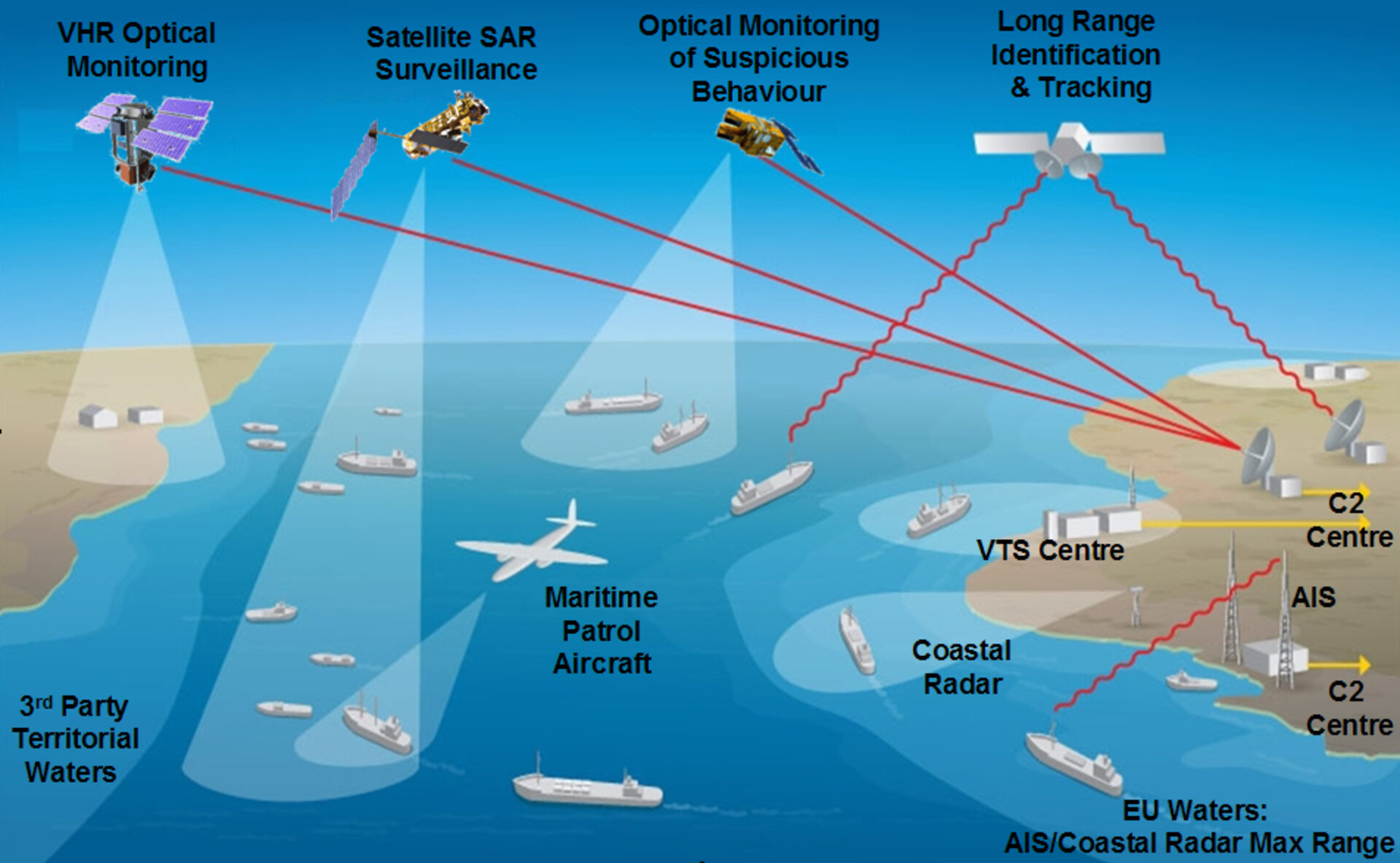


Abstract: The proliferation of satellites, both commercial and military, backed by powerful software and algorithms are providing militaries with new solutions to the age-old problem of intelligence, surveillance and reconnaissance (ISR). Coupled with artificial intelligence tools they promise a lot and in future, may also impact greatly on warfare at and from the sea. However, there is a case to be made for tempering down expectations based on the easy availability of commercial solutions or an improper understanding of their limitations. A closer look at historical data suggests that in times of crises, foreign, commercial services are as prone to denial and control as any other. Further, technical and market dynamics play a major role in their availability. Similarly, ocean monitoring tools on offer are also under strict government control without treaty obligations, they may be of limited utility. Artificial intelligence is another area that promises a lot but clearly without substantial investments, could fall short of expectations. Finally, military satellites have moved on from traditional ISR roles to targeting. However, these also have limitations and vulnerabilities which could be exploited. This article is an attempt to highlight some of the pitfalls in raising expectations and generate a debate. This would enable planners and policymakers to make a more realistic assessment of their utility and be able to exploit the large grey area that remains, effectively.
Introduction
Finding enemy ships and fleets at sea has always been a challenge. One may have read of the enormous amounts of time and effort Nelson spent, sometimes measured in months, searching for the French Fleet carrying Napolean's expedition to Egypt. Similarly, significant resources were spent trying to find the Bismark, in World War II. In the 18th and 19th centuries, frigates used to be positioned to 'cruise' outside enemy harbours for advance warning of fleet departures. However, since then there have been technological revolutions of sorts, enabled by radar, aircraft and now satellites that have made the frigate or even aircraft, in some cases, less suitable. With the proliferation of satellites today, some claim, we have reached or are fast reaching a stage where, using the example of illegal fishing, a commentator states there is nowhere for ships to hide.
Sitting far beyond the reach of conventional anti-air systems, satellites are effectively replacing aircraft not only for safer surveillance but also keeping a close eye on hitherto unreachable areas. With more and better satellites being launched every day, their battlefield utility is also improving in terms of the extent of areas under surveillance and the frequency, resolution of images, and time-latency. Countries in the lead include the US, China, some European countries, Japan, Korea and Russia. The availability of commercial satellite and ship tracking solutions in the market and the ease with which they can be 'ordered' also gives the impression that finding a ship at sea may be a matter of some quick searches and assimilation of data.
While no doubt, there is much to be optimistic about, and significant transparency may have already been achieved for commercial uses but, whether it also translates into the military domain, remains moot. In this article, an attempt has been made to look at some lesser examined aspects related to their use and examine the trend lines more analytically.
Commercial Satellite Market
As brought out, there has been a proliferation of commercial satellite service providers. These include Maxar, Airbus, ImageSat and PlanetLabs that provide electro-optical (EO) imagery; to ICEYE, Capella Space, Umbra Lab, and Synspective that sell Synthetic Aperture Radars (SAR) imagery. Also, there are Hawkeye 360 and Unseen Labs that use electronic intercepts to detect and localize 'dark' ships.
As of today, the resolutions of their images are not only adequate for surveillance, but also classification and identification for militaries. With new players emerging every day, better products are entering the market and competition is certainly getting intense. In fact, the competition is so tough that even the US Government (USG) has to continuously ease national security-related restrictions on commercial satellite imagery providers. As early as 1994, it was forced to remove the ban on the export of high-resolution imagery (up to 1m) due to "commercial reasons", "acknowledging it will soon be available widely". As late as Aug 2023, it had to loosen restrictions on selling X-band SAR data within a few days of which, Umbra announced the release of its 16 cm resolution SAR imagery. No coincidence! Realising the importance of these developments, the US Govt funds think-tanks to keep a hawk's eye on "commercial remote sensing capabilities" and publish annual reports complete with 'Global rankings' with an aim to "spur discussions on the state of U.S. leadership". As of 2024, China was on top with five golds out of 11, against US's four. India too has arrived at the starting blocks and interestingly, comes second in the Hyperspectral category with 'Anand', a satellite by Pixxel.
Challenges of Using Commercial Satellite Data
Though the competition and pressure may suggest that the "customer is king", what needs examination is the track record of such service providers in times of crises and the influence of national governments over them.
While, the US industry is undoubtedly averse to handing over a veto to the Department of War/ Defense studies have shown they would willingly cooperate or even assist the US military in "deceiving or disrupting information services" to its adversaries, and that they have been doing so regularly. The U.S. government possesses significant, legally backed capabilities to restrict, delay, or prevent the dissemination of high-resolution commercial satellite imagery, particularly when it poses risks to national security. These powers range from regulatory "shutter control" by the National Oceanic and Atmospheric Administration (NOAA), to contractual "buy-to-deny" methods by DoW/DoD. US licenses by NOAA retain conditions to protect national security at the request of the Secretary of Defense. Countries could also invoke international laws for the 'peaceful use' of space as an excuse, to deny services to an inconvenient belligerent even when not an adversary. In the worst case, governments could issue executive decrees in times of crises. For example, the French, under diplomatic pressure from the US, denied commercial imagery to the Iraqis in the 1990-91 Gulf war, to prevent exposing US CENTCOM troop concentrations about to execute the 'Hail Mary' manoeuvre. Recently, as part of pressure tactics, the US National Geospatial-Intelligence Agency suspended Ukrainian accounts from accessing US commercial satellite imagery.
Another problem is that most commercial constellations have a land bias (because most customers live on land?), resulting in huge gaps when it comes to the maritime domain. Even a cursory look at the imagery from Sentinel, which allows limited access on a free account, shows gaps beyond a few miles from land. While, these may include straits, choke points and areas close to the shore, they generally do not include open oceans, unless a demand for such data is placed.
Among other limitations are its prohibitive costs. The cost of one Maxar image is about Rs 3 lakhs which could go up, based on the resolution required. This would quickly eat up resources, if employed for 'search', for anything more than regular images of known or pre-defined areas like military harbours, bases and fixed infrastructure.
There is also the inescapable dilemma between resolution and swath that would drive up costs. If the positional ambiguity is large, a large swath image would be at the expense of resolution. Such images may be sufficient for detection, but not classification or identification, which would require additional resources or intelligence. To overcome this would require multiple high-resolution images, or for the planner to accurately predict the area to be imaged at the time of satellite pass. This could be many hours later. For a manoeuvring target, this would be expectedly difficult. Though technologies like tip-and-cue satellites are trying to plug the gap, the numbers required would be quite large even for advanced countries. Even in the commercial world, where multiple operators exist, they are teaming up to leverage each other's capabilities.
Prioritization of demands from competing commercial, governmental and military customers, limited capacities resulting in the need for multiple subscriptions and delays in demands fructifying, are other challenges when using commercial options.
So What? The discussions above highlight the dangers and limitations when using foreign, commercial satellite 'service providers'. Clearly, the commercial satellite market is as much a 'rules-based' world as any other and prone to being leveraged, as any other technology or capability. For a country like India, use of foreign commercial imagery for national security purposes needs to be done thoughtfully, especially for operational or tactical inputs. Robust data or intelligence sharing agreements may help to some extent, while continuing to nurture and improve upon existing and alternate capabilities (manned and unmanned aircraft, ELINT infrastructure, etc.). There is also no escaping the promotion of a robust, indigenous dual-use commercial satellite industry. These could be funded by the Government with subsidised operations through commercial means. The silver lining is that more Indian start-ups are boldly venturing into this niche field.
Ocean Reporting and Monitoring Initiatives
In addition to imagery, easy availability of white-shipping data (AIS information and access to ship registries), commercially, has also made oceans 'transparent' to some extent. The number of dots on the screen representing ships can certainly impress a layman. However, it is the 'dark' ships that interest a nation's police or armed forces. A few countries do possess such ocean monitoring solutions that use powerful software and algorithms to fuse data from multiple sources to detect such ships. The most well-known is the US SeaVision which correlates data from multiple open, commercial sources (EO, SAR, RF, VIIRS, AIS, VMS, etc.), to detect, classify and identify vessels at sea. However, the platform is controlled strictly by the US Government and granular information is provided only to allies and select partners. To India, it has offered it through the Indo-Pacific Maritime Domain Awareness (IPMDA) on payment and to some others gratis, as part of its Indo-Pacific strategy. However, in the words of a researcher, while it has found some success in the Pacific, practical achievements, especially in the Indian Ocean, have been minimal as countries, particularly in South Asia, remain hesitant to share sensitive information which may infringe on their national sovereignty. Differing legal frameworks, limited technological infrastructure, and the absence of clear protocols for accessing satellite data are other reasons.
Similarly, the French have their IORIS (Indo-Pacific Regional Information Sharing) that collaborates with SeaVision. India too is making headway with its Information Management and Analyses Centre (IMAC), which fuses information from open sources and radar networks. Relevant data is then shared through the Information Fusion Centre - Indian Ocean Region (IFC-IOR) with international partners. An agreement between the Indian and French space agencies (ISRO-CNES) would further enhance its capabilities in the future. Recently, the Indian Navy (IN) also launched its MITRA communication terminal with NISHAR application (akin to IORIS) to communicate and coordinate better with partner navies. As the number of indigenous space-based and other sensors increases, the utility of this platform will also grow.
A recent commercial initiative is the Global Fishing Watch (GFW), to tackle the issue of illegal fishing. It uses the Visible Infra-red Imaging Radio Suite (VIIRS) originally developed by US NOAA and NASA, to detect fishing boats that use bright lights at sea. The algorithms for this venture were developed by NOAA. However, as per a study it has obvious limitations. While it can detect various light sources at sea, it cannot detect "modest light sources that commercial vessels in transit put out." This puts detection of warships, using this method, in further doubt. Though it also uses AI/ ML, it does so only to detect anomalous behaviour from data, which is largely disclosed voluntarily through the automatic identification system (AIS). Clearly, the transparency some perceive, as mentioned earlier, due to the proliferation of little dots on our screens is purely and misleading and of limited value to national security stakeholders. Even ships involved in regular trade regularly go 'dark' and form part of 'shadow fleets', let alone those hundreds involved in illegal or illicit activities.
So What? Countries like US and France provide access to their platforms based on geo-political considerations which, as the world realises, can change quickly. Further, while these provide world-wide AIS data (voluntarily disclosed) to partner countries, information on 'dark ships' is strictly controlled and requires intelligence sharing agreements for access, but with no control over the quality and frequency of sharing such data. Considering China's intent in raising the Strategic Support Force (SSF) to move from 'informationised' to 'intelligentised' operations, it can reasonably be assumed that China has or would soon have this capability. Clearly, foreign or commercial multi-source or multilateral platforms will have limited use in building situational awareness, mostly for constabulary purposes. Entering into treaty obligations with partners, in the short term, and developing similar indigenous capability in the long term, are the only way ahead for reliable use.
Artificial Intelligence and Machine Learning
Many well annotated satellite imagery data are being uploaded by many so-called OSINT experts and influencers that appear to have been made using AI/ ML tools. However, there are lesser-known aspects of AI/ ML that need further examination. Take the example of GFW. As per their claims, they "manually labelled over a thousand vessel tracks (more than 70,000) to train our fishing detection model", but this was only a fraction of the estimated 2.9 mn 'motorized' fishing vessels that exist. The point that this highlights and which falls through the cracks in uninformed discussions, is the hugely challenging task of training a 'neural network (NN)' (the core of any AI/ ML machine). Secondly, each NN is generally trained for a specific narrow task. An NN that identifies cats cannot identify dogs because it is not trained to do so. Of course, things are improving by the day (Convolutional NNs, Deep Learning, Generative AI, etc.) and as we pack in more transistors per silicon wafer ('Moore's Law'), things would become easier. However, suffice to say that challenges remain.
Firstly, any NN requires huge amounts of error-free data without which, AI systems are destined to fail. The phrase "garbage in, garbage out" perfectly captures this reality. If the data fed is flawed, incomplete, or irrelevant, the resulting insights and predictions will be equally flawed. Secondly, ML machines that some assume to be self-learning, need experienced human data scientists to frame the problem, prepare the data, remove potential bias and, most importantly, continually re-train the NN, based on the errors generated and new data encountered. At the stage of development, apart from large amounts of data, a large pool of trained manpower is required to make a reliable ML product. Once developed, to a certain degree of satisfaction, it may then seem seamless, obvious and easy to the user. For example, it took OpenAI more than six years and large amounts of data (and huge fluctuations of the stock market) to transform its GPT (Generative Pre-trained Transformer), a large language model (LLM) based natural language processor (NLP), into a reliable AI engine.
Image recognition, another specialized field of AI, works in the domain of ML and DL, and has similar challenges in ship detection using satellite imagery. Accuracy levels and success rates depend a lot on the lighting, perspective, angle, occlusion, etc., when using real-world data. Accordingly, in some narrow tasks (facial recognition, crack detections,radiographies, etc.) these have already started showing promise, however, they have some way to go before they can beat an image specialist in accuracy and consistency, in other fields. The substantial computing power to sift through images streaming in from each satellite and the specialised hardware required for the job are other challenges. The defence white paper of China claimed in 2019 that 'informationised conflict and intelligent warfare' was 'on the horizon', suggesting it was not there yet, though, it is likely to have come a long way since.
So What? AI/ ML is making a huge difference in the way data is being interpreted and the speed with which analysis is possible. However, these are at the expense of huge amounts of time, manpower and money being invested by advanced navies. Current success rates of image recognition tools make tactical or operational decision making unreliable and would put a strain on limited resources. To leap-frog competition in this area of emerging technology, it may not just suffice to adopt solutions available in the market but develop better ones before others. This will require substantial resources.
Military Satellites - Targeting
Without going into too much detail, it would suffice to say that developments on the commercial side provide indications of the capabilities that might be available in the military domain. Their utility in detection, classification and identification has been established and is quickly maturing towards enabling targeting.
While assessing China's capabilities in 2014, using simulations of available Chinese ELINT, EO and SAR satellites, in various combinations, professors from the National Institute of Advance Studies, Bangalore, deduced that the available space-based surveillance system could identify, locate and track an Aircraft Carrier Group with an accuracy of 10 km.
A similar analysis in 2016, by Gosnold, a French blogger who runs a highly popular website, claims that "China has optical, radar and electronic capabilities to detect, identify and track ships at sea. Its optical and SAR constellations can find contacts in a vast area every day and have a good chance of refreshing the location of the most interesting ships every few hours. Consequently, it seems unlikely a naval group could hide in the ocean for long."
Another report prepared in 2020, by Project 2049 Institute, a Virginia-based think tank, focusing on China assessed that "increasingly greater spatial resolution and an ability to monitor U.S. activity in the Indo-Pacific region (including the locations of U.S. aircraft carrier battle groups) in all weather conditions is likely to enhance China's ability to conduct military operations farther from shore. Space-based sensors also provide the data necessary for mission planning functions, such as terminal guidance for ballistic and land attack cruise missiles."
Further, there is enough evidence now to suggest that China has a proven anti-ship ballistic missile (ASBM) capability. It reportedly carried out a series of tests of its ASBM arsenal in Aug 2020 which, for the first time successfully hit a moving ship. Clearly, today satellites are not only helping in classical ISR roles during major operations, but also in direct targeting roles. However, as remarked by some, the jury is still out on whether the entire chain of activities can be achieved repeatedly and consistently in a real-world scenario.
What one may infer is that the satellite density required to cover every corner of a battlefield may yet not have been achieved for a moving target, without help from other capabilities. Moreover, satellites have their own limitations and vulnerabilities. The limitations include camouflage, deception, cloud cover and darkness for EO/ IR satellites; emission control for ELINT satellites; and the dilemma between resolution and swath for SAR satellites. A measure of their limitations can be made by a cursory look at the number of manned and unmanned aircraft sorties being flown in various theatres of operations like Ukraine, Afghanistan, Persian Gulf, South China Sea, etc., suggesting that satellites have augmented ISR but cannot take over the role. Further, satellites would also be vulnerable to counter-satellite (camouflage, decoys, jamming, dazzling) and anti-satellite (kinetic takedowns, capturing, de-orbiting) measures. These could be exploited too with methods getting innovative by the day.
So What? No doubt satellites are greatly assisting in solving the problem of locating, classifying and identifying ships at sea for advanced countries. In addition, China has demonstrated the ability of hitting a moving ship with a missile. However, the problem is unlikely to have been fully resolved. A pragmatic assessment of the adversary's satellite capabilities, including the support it gets from others, would therefore have to be made to assess its real impact for which, intelligence on these would be crucial. Full and complete adoption of satellite evasion and counter- and anti-satellite measures also need to be made by operational planners.
Implications for India
The emergence of space as a new domain is by now established. The domain will continue to grow, and satellites fused with AI/ ML will continue to evolve as well. There are, therefore, several implications for countries like India. Firstly, there is no option but to put in concerted efforts at developing these technologies both for commercial and military fields through investments in industry, academic and research and development spheres. In addition, we need to build up steam in promoting a robust, dual-use commercial industry with good regulatory mechanisms defining usage and sale of data to third parties.
In the interim, we would have to rely on foreign or commercial solutions while treating such information with caution and understanding its limitations and pitfalls. Treaty obligations, if possible, or robust intelligence or data sharing agreements, would be necessary to overcome data assurance and reliability problems, but treaties come with attendant issues as well. The data would have to be supplemented with continuous improvements in other existing capabilities like aircraft, ELINT, etc.
Similarly, one would have to put in considerable efforts in the field of AI/ ML to make satellite image detection and recognition reliable for operational and tactical use. This would require indigenous technological innovations and allocation of necessary resources.
Moreover, investing in counter- and anti-satellite technologies and measures and adopting them in daily operational/ tactical planning needs to become second nature.
As the field grows, we also need to ponder whether this domain can remain adjunct to a particular service or whether it needs to come out of the shadows, as an independent service with its civilian components. US and China have already shown us some organizational models which could be examined.
Finally, for military commanders caught in the present, the importance of military planning, age-old principles of war, honest examination of all inputs and analyses of a growing number of factors, etc., cannot be over-emphasised. The 'factor' of satellites may increase the constraints against a more technologically advanced adversary but, solutions will have to be found through rigorous application of traditional operational planning tools, in the absence of the necessary coup d'oeil.
-
Gavin Haines, “No Place to Hide’for Illegal Fishing Fleets As Surveillance Satellites Prepare for Lift-Off,” Mongabay, August 30, 2019, https://news.mongabay.com/2019/08/no-place-to-hide-for-illegal-fishing-fleets-as-surveillance-satellites-prepare-for-lift-off/.
-
‘Dark’ ships are those that stop broadcasting its position via AIS to conceal their location or identity.
-
Refer to respective company websites. The best optical commercial imagery available, as of today, is provided by Maxar (15 cm), while the Chinese constellation SuperView Neo provides imagery of 30 cm resolution. The best SAR imagery is by Umbra (16 cm).
-
“Global Competitiveness in Commercial Remote Sensing: An Overview of 2024 Rankings,” New Space Economy, October 14, 2024, https://newspaceeconomy.ca/2024/10/14/global-competitiveness-in-commercial-remote-sensing-an-overview-of-the-2024-rankings/.
-
Theresa Hitchens, “NOAA Eases Licensing Restrictions on Commercial Remote Sensing,” Breaking Defence, August 09, 2023, https://breakingdefense.com/2023/08/noaa-eases-licensing-restrictions-on-commercial-remote-sensing.
-
Anthony J Russo, The Operational Denial of Commercial Space Imagery (Fort Leavenworth, KS: US Army Command and General Staff College, June 07, 1996), https://apps.dtic.mil/sti/citations/ADA312544/.
-
Theresa Hitchens, “NOAA Eases Licensing Restrictions on Commercial Remote Sensing.”
-
Kari A. Bingen, David Gauthier and Madeline Chang, “Gold Rush: The 2024 Commercial Remote Sensing Global Rankings,” Centre for Strategic and International Studies, October 01, 2024, https://www.csis.org/analysis/gold-rush-2024-commercial-remote-sensing-global-rankings.
-
Kari A. Bingen, David Gauthier and Madeline Chang, “Gold Rush: The 2024 Commercial Remote Sensing Global Rankings.”
-
Anthony J Russo, The Operational Denial of Commercial Space Imagery.
-
Denetter L. Sleeth, “Commercial Satellite Imagery Threat: How Can U.S. Forces Protect Themselves,” U.S. Naval War College, February 09, 2004, https://apps.dtic.mil/sti/pdfs/AD A422750.pdf
-
Tom Patton, “Commercial Remote Sensing Satellite Licenses Modified by NOAA,” The Journal of Space Commerce, August 09, 2023, https://www.exterrajsc.com/p/commercial-remote-sensing-satellite-licenses-modified-by-noaa, also United States Department of Commerce, National Oceanic and Atmospheric Administration (NOAA), Guidance for NOAA Commercial Data Buys (2024), https://www.nesdis.noaa.gov/s3/2025-08/NOAA-Commercial-Data-Buys-Guidance-2024.pdf.
-
Russo, ibid.
-
S. Latchford, Lt. Col., U.S. Air Force, Strategies for Defeating Commercial Imagery Systems, Occasional Paper No. 39 (Center for Strategy and Technology, Air University, December 2005), https://apps.dtic.mil/sti/pdfs/ADA46346 8.pdf.
-
Reuters, “U.S. Govt Revokes Some Access to Satellite Imagery from Ukraine,” Al Arabiya English, March 08, 2025,, https://english.alarabiya.net/News/world/2025/03/08/us-government-revokes-some-access-to-satellite-imagery-for-ukraine/.
-
Soumya Pillai, “Orders for Pahalgam Satellite Images from US Firms Peaked Two Months Before Attack,” The Print, May 09, 2025, https://theprint.in/defence/pahalgam-satellite-image-us-space-tech-firm-maxar-technologies/2620666/.
-
Debra Werner, “How Earth Observation Satellite Operators are Teaming Up to Tip and Cue One Another,” Space News, https://spacenews.com/how-earth-observation-satellite-operators-are-teaming-up-to-tip-and-cue-one-another/.
-
Gosnold, “The Future of Earth Observation Part II, Satellite Observation, (blog), July 10, 2016, https://satelliteobs ervation.net/2016/07/10/the-future-of-earth-observation-ii/.
-
Since 2014, the number of startups has increased to 400 and investments have crossed USD 500 mn. Some of the prominent names include, M/s. Pixxel, M/s. Dhruva, M/s. Skyroot Aerospace, M/s. Agnikul Cosmos, M/s. Bellatrix Aerospace etc. India, Department of Space, “Space Startups in India,” Press Information Bureau (PIB), February 11, 2026, https://www.pib.gov.in/PressReleasePage.aspx?PRID=2226234®=3&lang=1. Andrew Jones, “India Targets a Surge in Civil and Commercial Launches,” SpaceNews, February 16, 2024, https://spacenews.com/india-targets-a-surge-in-civil-and-commercial-launches/.
-
Abhijit Singh, “Quad’s Maritime Vision Short on Strategic Intent,” Observer Research Foundation, October 07, 2024, https://www.orfonline.org/research/quad-s-maritime-vision-short-on-strategic-intent.
-
“Indo-Pacific Regional Information Sharing (IORIS) Platform,” IORIS, https://ioris.org/.
-
Wikipedia contributors, “Information Management and Analysis Centre,” Wikipedia, https://en.wikipedia.org/wiki/Information_Management_and_Analysis_Centre.
-
Guillaume Gandelin, “Forging the Next Frontier in India-France Space Ties,” Observer Research Foundation, February 06, 2026, https://in.ambafrance.org/Agreement-to-establish-a-maritime-surveillance-centre-in-India.
-
Ministry of Defence, Government of India, “Global Community Must Collectively Aspire for Peace in This Age of Democratic & Rules-Based World Order: Raksha Mantri Shri Rajnath Singh at Exercise MILAN in Visakhapatnam,” Press Information Bureau (PIB), Delhi, February 21, 2024, https://pib.gov.in/PressReleasePage.aspx?PRID=2007789, accessed 14 Mar 26. Nirbhay Bapna, “Africa India Key Maritime Engagement (AIKEYME): Transforming Maritime Security in the Indian Ocean Region,” Indian Naval Despatch 5 No. 3 (Aug 2025): 22-34. https://www.indesfoundation.in/indes/indian-naval-despatch-vol5-no3/2.
-
Gregory B Poling, “From Orbit to Ocean – Fixing Southeast Asia’s Remote Sensing Blind Spots,” US Naval War College Review 74 No.1, Article 8 https://digital-commons.usnwc.edu/nwc-review/vol74/iss1/8/.
-
Andrew Roth, “The ‘Dark Fleet’ of Tankers Shipping Russian Oil in the Shadows,” The Guardian, August 19, 2023, https://www.theguardian.com/business/2023/aug/19/the-dark-fleet-of-tankers-shipping-russian-oil-in-the-shadows.
-
David A. Kroodsma et al, “Tracking the Global Footprint of Fisheries,” Science 359 No. 6378,(2018): 904-908.
-
David A. Kroodsma et al, “Tracking the Global Footprint of Fisheries.”
-
Anish Athalye et al., “Fooling Neural Networks in the Physical World with 3D Adversarial Objects,” LabSix, October 31, 2017, https://www.labsix.org/physical-objects-that-fool-neural-nets/.
-
Ventsi Todorov, “Why Quality Data is One of the Biggest Challenges in Building AI Solutions,” Ninetwothree (AI consultancy blog), Oct 03, 2024, ninetwothree, AI consultancy firm, https://www.ninetwothree.co/blog/why-quality-data-is-one-of-the-biggest-challenges-in-building-ai-solutions.
-
Andrew Ross, “Garner: Debunking Five Artificial Intelligence Misconceptions,” Information Age, February 14, 2019, https://www.information-age.com/five-artificial-intelligence-misconceptions-12868/.
-
Marcin Kapuscinski, “Evolution of AI: From GPT-1 to GPT-4, Key Features, Milestones and Applications,” TTMS, June 11, 2024, https://ttms.com/my/evolution-of-ai-from-gpt-1-to-gpt-4o-key-features-milestones-and-applications/.
-
Christina Sikes, “The Enigma of AI’s Image Struggles: Uncovering the Reasons,” Elite SEO Consulting, January 31, 2025, https://eliteseoconsulting.com/seo-pricing-packages-2free-seo-consultation/.
-
Stephen Panev, “Challenges and Solutions in Training Deep Learning Models,” Data Science Society, https://www.datasciencesociety.net/challenges-and-solutions-in-training-deep-learning-models/, GeeksforGeeks, “Challenges in Deep Learning,” https://www.geeksforgeeks.org/deep-learning/challenges-in-deep-learning/.
-
The State Council, People’s Republic of China, “China’s National Defence in the New Era,” Xinhua, July 24, 2019, https://english.www.gov.cn/archive/whitepaper/201907/24/content_ WS5d3941ddc6d08408f502283d.html.
-
Soma Perumal Chandrashekhar, “China’s Constellation of Yaogan Satellites and the ASBM,” National Institute of Advance Studies, January 22, 2014, https://cms.nias.res.in/publications/chinas-constellation-of-yaogan-satellites-the-asbm.
-
Gosnold, “The Chinese Maritime Surveillance System,” Satellite Observation (blog), September 20, 2016, https://satelliteobservation.net/2016/09/20/the-chinese-maritime-surveillance-system/.
-
Mark Stokes, Gabriel Alvarado, et al., “China’s Space and Counterspace Capabilities and Activities,” Project 2049 Institute, March 30, 2020, https://www.uscc.gov/research/chinas-space-and-counterspace-activities.
-
Steven Stashwick, “Chinese ballistic missiles fired into South China sea claimed to hit target ship,” The Diplomat, November 17, 2020, https://thediplomat.com/2020/11/chinese-ballistic-missiles-fired-into-south-china-sea-claimed-to-hit-target-ship/, Ronald O’Rourke, “China Naval Modernisation: Implications for US Naval capabilities – Background and Issues for Congress,” Congressional Research Service, April 24, 2025,https://sgp.fas.org/crs/row/RL33153.pdf.
-
Thomas R McCabe, USAFR (Retd), “Chinese Intelligence, Surveillance and Reconnaissance Systems,” Journal of Indo-Pacific Affairs 4 No. 1, (Spring 2021), https://www.airuniversity.af.edu/JIPA/Display/Article/ 2528263/chinese-intelligence-surveillance-and-reconnaissance-systems/.
-
A.S. Bahal, “Satellite Reconnaissance, ISR and Countermeasures,” Air Power Journal 3 No.2 (Summer 2006) https://capssindia.org/wp-content/uploads/2022/10/Bahal-AP.pdf.
-
Coup d'œil (French for "stroke of the eye") is a military term for a commander's innate ability to instantly assess a complex battlefield, recognizing terrain advantages, enemy weaknesses, and optimal tactical moves. It is described as "at-a-glance leadership" and strategic/ tactical intuition.
